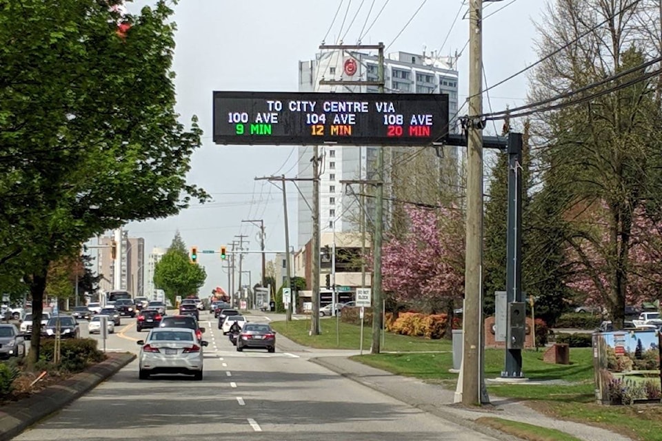
Three signs in the city’s northwest will help motorists decide which routes to take when driving into Surrey’s downtown.
The City of Surrey launched its three Advanced Traveller Informational System (ATIS) signs Tuesday (Dec. 3), which is meant to help drivers “make more informed decisions to improve their commute, reduce the environmental impact of driving, and lessen driver frustration,” according to a release from the city.
The three overheard, coloured signs “are situated to provide adjacent route choices for City Centre drivers arriving from Highway 1 in the north and Highway 99 in the south.”
The signs are located at:
• 154A Street for westbound drivers along 104th Avenue, providing route options via 100th, 104th and 108th avenues
• Just south of Highway 10 for northbound drivers on King George Boulevard, displays route options via King George Boulevard and 132nd and 140th streets
• The 152nd Street off-ramp from Highway 1 eastbound for southbound drivers, provides route options via 100th, 104th and 108th avenues
The report states that “due to the expected residential and job growth of City Centre and its emergence as the region’s second downtown core, the route for all DMSs (Dynamic Message Signs) was selected to be City Centre.”
READ ALSO: New SFU Surrey projects aims to help position City Centre as region’s second downtown core, Oct. 2, 2019
The signs, according to the city, display travel times from data collected and analyzed from 50 Bluetooth sensors installed in 2018 at selected traffic lights throughout the city’s northwest.
The ATIS detects the Bluetooth devices, encrypts the data and routes it to the Traffic Management Centre, “where a computer tracks the speed and travel time of the detected devices as they move through the city.”
“A comparison of real-time speeds to historical speeds alerts staff when road links are travelling slower than normal, and traffic signals are then adjusted and the public is alerted to changing traffic conditions,” the release reads.
This new system is supported by TMC traffic engineers and technologists who actively manage more than 2,500 traffic devices across approximately 316 square kilometres of city space.
ATIS will fully integrate with the city’s other systems, including the exclusive wireless radio communications system, nearly 500 traffic cameras, and over 410 networked traffic signals to improve safety and travel times, according to the release.
The ATIS project, which cost $1.5 million, will be shared equally between the City of Surrey and Transport Canada.
A corporate report from the city states Transport Canada’s portion comes from its Asia-Pacific Gateway Corridor Infrastructure fund “for the implementation of an innovative and leading-edge ATIS in order to improve the flow of goods and people throughout Surrey.”
The citys portion, according to the report, comes from the 2018 and 2019 Transportation budget. The costs for maintenance and operation of the system has been included in the 2020 Financial Plan.
Jaime Boan, manager of transportation for the city, said the original budget for the project came in at $1.84 million, so the project is “well under budget.”
The cost for the signs, he said, was $700,000, adding that the 50 Bluetooth sensors were also a “considerable cost.”
As for the continued costs for operation and maintenance, Boan said that is to be determined.
“We don’t expect to be much cost in the early years. As it ages, we obviously have to plan for replacement,” said Boan, adding that staff expect the signs to last at least 10 years.
READ ALSO: Surrey installs digital information signs for drivers, March 1, 2019
The city first announced the signs back in February, through a tweet on the Surrey Traffic Twitter account.
At the time, the city said it was hoping the signs would go live “by spring.”
Boan said since it’s “leading-edge” technology, staff had to make sure everything was “working perfecting.”
“There was some issues along the way, which led to it taking quite a bit longer than anticipated,” he said.
A map of Surrey’s Advanced Traveller Information System (ATIS) Dynamic Message Signs and the Bluetooth sensors, which are located in the city’s northwest. (Map: City of Surrey)
lauren.collins@surreynowleader.com
Like us on Facebook Follow us on Instagram and follow Lauren on Twitter